BLOGGER TEMPLATES AND IMVU Layouts »

Saturday, August 25, 2012

Battle Statistics

For anyone who cares....namely me (who needs this so she doesn't lose her mind trying to keep track of all these numbers!).....these are the numbers of fighters on the Good Guys Side and the Bad Guys Side (most are roughly estimated, of course) for my story "Brono a Chuio".


Rebels (Good Guys)

Northern Dragons (6 fighting)
Sand Dragons (3 fighting)
Char-pyk Dragons (155 fighting)
Tsubasa (4 fighting)
Twanres (50 fighting)
Vultsi (23 fighting)
Maia (1 fighting)
Rangers (3 fighting)
Haradrim Men (6100 in all - 500 archers, 3000 horsemen & 2600 foot soldiers)
Rhunic Men (7400 in all - 400 Ab-Gribyl, 3000 Ak-Jnab, 1000 Khand, 3000 Rebels)

13,745 Fighters in all roughly estimated


Dark Lord Troops (Bad Guys)

Dark Dragons (1 fighting)
Vy-kror Dragons (400 fighting)
Maia (1 fighting)
Sertek (6500 fighting)
Empath Serket (30 fighting)
Rhunic Men (7700 in all - 4200 Al-Salyha & 3500 Ar-Hihn)
Fell Beasts (330 fighting)
Empaths (15 fighting)

15,077 Fighters in all roughly estimated


Rebel Army

*Rebels riding Char-pyk and Sand dragons form the first line of defense and will engage Sertek (and Vy-kror) as their prime enemy.

*Rebels and Haradrim riding horses form the second line of defense and will engage Sertek (and Vy-kror) that the Char-pyk do not catch.

*Rebels and Haradrim on foot/archers form the third line of defense and will engage men in Kilicar's army and Sertek (and Vy-kror) that get past the first two lines.

*Vultsi commanded by Maltaserce and Tsubasa/Twanres commanded by Osamu form the forth line of defense. The Vultsi will fight anything, but their main enemy will be the fell beasts in the sky. The Tsubasa and Twanres will engage any enemy, but will most-likely focus their attention on the Sertek.

*Northern Dragons form the last and fifth line of defense and will engage with sky-enemies, occasionally lending assistance to those on the ground.


Dark Lord's Army

*Vy-kror and their Riders will form the first line of attack.

*Sertek will form the second line of attack and will proceed in groups according to species (ie. Humanoid, Felines, Canines, Reptile, Bird)

*Empath Sertek form the third line of attack.

*Rhunic Men and Empaths will form the forth line of attack.

*Fell beasts and the Dark Dragon will form the air and fifth line of attack.

Sunday, August 5, 2012

Map of Avarikal


CLICK ON ANY PICTURE TO VIEW FULLY or right click with your mouse/touch pad and select "view image" for full view of the picture. (Scroll down this blog page to see map of Rhun and Harad.)


This map is of Avarikal, a land to the utmost East of Arda, past Rhun and the Orocarni Mountains. Middle-earth is owned and created by J.R.R Tolkien. I simply created this map for my own enjoyment and use, to depict a land unnamed in the T.A. of Lord of the Ring's literature. All names, forests, cities, rivers and lakes are the property of me (with the exception of the Orocarni and the East Sea). This vague land in general (in the books) is Tolkien's


 Avarikal.

The Orocarni Mountains are the natural and formidable divide between Avarikal and Rhun. The great forest of Makitalad is located on the eastern slopes of the red mountains. Ciele, Home of the High Anikrrn is located in the middle of Makitalad Forest.

The river, Merdagsa, to the south, is fed by Rávasisne, the large mountain lake in the Orocarni. The Merdagsa flows into the Matarik Bundak, the gray mountains. The river Mornakat in the north runs into the East Sea. The river Hatisir originates from the Matarik Bundak and flows into the East Sea.

The plains of Gibulac stretches out to the borders of these three rivers. The Gibulac is an unsteady mix of solid fields and marshland, many small rivers and streams making the ground treacherous as they flow underground and out to sea.


 In this shot:

The largest forest of Tumnalda (to the north-west) is visible. The river Hatisir runs through these woods until it flows into the Sapotwë delta. The smaller forest to the east of Tumnalda and near the Lithurol hills is called the Ëaralis. The second-largest forest to the east and near the East Sea is the Lhosavar. The twin forests below the Lhosavar are called Pulonîdh (left) and Maiwë, (right). The medium-sized forest under Tumnalda and Lhosavar is the Laiquahiyas.

The small river, Liwailin, runs through both Laiquahiyas and Lhosavar on it's way to the sea. It originates from the river Hatisir.

The island of Macéva Lupa is located in the eastern part of the East Sea. It is the largest island in Avarikal and is also a city. The Piacéva Lupa is the smaller island in the northern part of the East Sea that claims Avarikal as it's kingdom.

There is a sea-side city called Aralenin in this shot. It is located to the north of Tumnalda. There are two forest-villages and one forest-city located in Tumnalda. The forest-villages, called Pia Nayon (left) and Thúlë (right), are located on the west side of the Hatisir river and the forest-city, called Sariya, is located on the east side of the Hatisir river.

In the forest Lhosavar there are two forest-cities and their names are Halatir (top) and Sinagalca (bottom). The forest Maiwë has one forest-village called Agila. The forest Laiquahiyas has one small forest-city named Tahilor.

The gray mountains, Matarik Bundak, are glaringly visible to the south.


In this shot:

 Part of the Tumnalda forest is visible, as is the 'dividing river, Hatisir. To the left of the Hatisir river is the marshland-plains of Gilubac. Many small, only locally named, rivers branch out from the three major rivers in the area. Their names are Hatisir (to the east), Merdagsa (south) and Mornakat (north). The small split in the river Merdagsa is named Kacelu.

The large lake, Rávasisne, is located in the Orocarni Mountains.

The small forest near the East Sea and south of the Mornakat is called Nénaurë. The greatest forest in Avarikal, the Makitalad, is located to the west, on the eastern borders of the Orocarni Mountains.

There is one sea-side village and one sea-side city in this shot. One, Dagatithë (village), is located to the north of the Mornakat river. The other, Aralenin (city), is located north of the Tumnalda forest. There are two forest-villages visible here as well. They are both located in Tumnalda, both are west of the river Hatisir and they are named Pia Nayon (left) and Thúlë (right).


Tuesday, July 10, 2012

Map of Harad

CLICK ON ANY PICTURE TO VIEW FULLY or right click with your mouse/touch pad and select "view image" for full view of the picture. (Scroll down this blog page to see map of Rhun.)


This is my map of Harad. Harad is a land to the far south of Middle-earth and is owned and created by J.R.R Tolkien. I simply created this map for my own enjoyment and use. All names, forest, cities, rivers and lakes are the property of me. Harad in general is Tolkien's.

The mountains you see are simply called the Gray Mountains or Ered Mithrin. The city of Umbar, the main city of the Corsairs, lies next to the sea. They are one of the enemies of Gondor.

The upper portion of the map is Near Harad and the bottom portion is Far Harad. The Jungle of Nrapir lies in the middle. The western portion contains the Deep Jungle and the eastern portion contains the East Jungle.

The River Inkarwirn flows through Near Harad and the Nrapir Jungle. The smaller river that flows into Citroprn Lake is called the Harlarink. The smallest river flowing out of the lake is the Gretyn.

There are four main cities around the Citroprn Lake, the royal city being called Cjornark (located on the eastern side of the lake). The royal city is followed by Xanrewuq (also on eastern side), Nremesirn (western side) and Inhartwin (western side).

The small road Rur Trun Wirn is the only intact road that leads from Nremesirn to the Citroprn Lake. The three forests of Lovirark (biggest forest, north side of lake), Zasik (south side of lake) and Bjorkhara (western side of lake) are the main sources of wood and food for the inhabitants of the four cities.

Map of Rhûn

CLICK ON ANY PICTURE TO VIEW FULLY or right click with your mouse/touch pad and select "view image" for full view of the picture.


This is Rhûn (my version), a land to the far east of Middle-earth. Rhûn was created and is owned by J.R.R Tolkien. I simply created and added to his creation for my own enjoyment and benefit. Names you do not recognize are created by me.

Full picture of map, further away. The Ered Aearon (the dark mountains) are located on the western side of the Sea of Rhûn and they are named in the elven tongue and not the Rhûnic tongue. The tiny, tiny river on the eastern side of the Ered Aearon (you might not be able to see it) is called the Pronir.

Close up.

In this shot, the forests of Bik Grov o Dolo (far north), Procalor (small forest to the west of Bik Grov o Dolo), Narketil (at the base of the red mountains) and Calorgrov (near the sea) are visible.

The Rhes o Ainek River, which flows from the Orocarni Mountains, feeds into the Sea of Rhûn from its eastern side. The four mountains of Lyt, Osn, Carsk and Nar are all together and the twin mountains Baya and Bryn are nearer the plains.

The Kingdom of Al-Salyha is near the twin mountains Baya and Bryn. The Kingdom of Ar-Hihn is located in the west-south corner of Bik Grov o Dolo.

In this shot, the small lake Luusa is visible as is the Ceplina River (to the south) and again, the Rhes o Ainek River (to the north). The forest of Gleritar is near the lake, Luusa, and next to the Kingdom of Al-Salyha.

The dark, but abandoned Kingdom of Morduath is located in the east-south corner of the map along with the mountain Ogiil. The Kingdom of Ak-Jnab, a desert Kingdom made up of tribes, is located on the southern shore of the Ceplina River. The Kingdom of Ab-Gribyl is located on the eastern shore of the Sea of Rhûn.

A few things not shown in writing on the map are the green plains between the Sea of Rhûn and the Orocarni Mountains (called the Vintael), the split in the Ceplina River where the river meets the Sea of Rhûn (called the Vizix Fork), a crossing in the middle of the Ceplina River (called the Groron Bridge) and a crossing of the Ceplina River to the east, by the mountains (called Morlyt Way).


Wednesday, April 18, 2012

Kahilnar Art

CLICK PICTURE TO VIEW FULLY

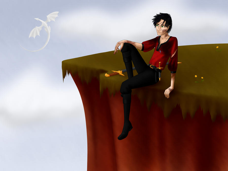
This is Kahilnar. He is the Crown Prince of Al-Salyha, Rhun. He is also known as the Roniysr (Heart of the People) and the Prince of Rhun. He is part Human (62.5%), Dragon (25%) and Elf (12.5%). He has black hair, green eyes that change to black when his birth-power (mind-reading and other mind abilities) comes into play and a dragon-gift that involves water. Kahilnar is bonded to the battle dragoness Sharpmist. He has two full-blooded sisters, Nareke and Yileke. Two half-sisters, Katun and Mahayre, and three half-brothers; Sacalnun, Kilicar and Edgu. Kahilnar is sharp-tempered, swift of mind and stubborn, but is learning loyalty, trust and above anything else, patience.

(And yes, that is Sharpmist in the background)

My friend, Whisperwings, http://whisperwings.deviantart.com/ made Kahilnar for me! Go check her out! Her art is amazing!

Sunday, April 1, 2012

Noruiel Art

CLICK PICTURE TO SEE FULLY!!

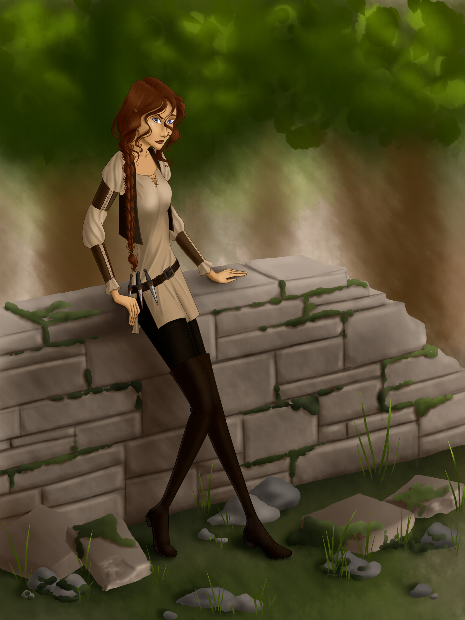
This is Noruiel "Nori". She is half-elven and she is what's called an Ikatla Akira (Third Level Empath and only one peg lower than the most powerful - an Ekaapa Akira). She as blue eyes that change from the many shades of blue to the many shades of brown with her emotions. She is 86 years old, has a father, three brothers and one sister. Nori is tiny, spirited, stubborn and hates to lose a challenge. She is dedicated to my future sister-in-law, "Eirien".

My friend, Whisperwings, http://whisperwings.deviantart.com/ made Noruiel for me! Go check her out! Her art is amazing!

 
Site Meter